DJI Terra
DJI Terra - Digitize the World
Analyze and visualize your environment with DJI Terra, an easy-to-use mapping solution for industry professionals to professionally generate digital data from real-world scenarios.
Plan Processing Analyze and Execute
- Planning of flight orders
- data collection
- area mapping
- data analysis
Order
types Waypoint planning
Create efficient flight routes with predefined actions at the respective waypoints. Key features such as speed, altitude, and gimbal alignment can be set before the flight. For more complex flight orders and flights in confined spaces that require a high level of detail, a 3D flight visualization is now available to plan and simulate flights in existing 3D models. 
Planning
In just a few steps, complex flight orders can automate what creating maps and models for further analysis much easier. 
Oblique view Planning
When precision is essential and high levels of detail are essential, flying jobs with angled images make it possible to create true-to-detail 3D models. Here, the camera takes pictures from a tilt angle to get an even sharper and more detailed image of the target object. 
Mapping
mapping in real-time
mapping in real time provides the ability to quickly create a 2D ortho mosaic of a selected area. This is not only ideal for creating detailed flight routes in remote areas, but also for jobs with limited time slots. 
2D Reconstruction
Generate high resolution orthomosaic images for accurate measurement results on important projects. 
3D reconstruction
Get a crisp and realistic representation of an area. This technology can be used for a variety of industrial applications, such as construction progress and accident reconstruction.
Data Analysis
2D and 3D Measurements:
Capture the dimensions of a range of user-friendly distance, area, and volume measurement tools.
Annotations
Add annotations to existing models, which can help improve communication throughout a project.
Detailed Photo Inspections
Photos with a 3D reference point can be viewed separately on demand. The 3D models and photos data give you more freedom to inspect and double-check details. DJI Terra
Start a new generation of mapping solutions Take
advantage of the latest mapping solutions with AI technology and take industrial projects to a new level of capability. Be it object classification or inspections, develop task-specific mapping solutions to complete your jobs.
Data collection
Define goals, plan flight orders and automate data collection from the air.
data processing
Leverage image recognition technology and generate 2D and 3D data for a more realistic representation of your target, the environment, or your entire infrastructure.
Data
Utilization Use machine learning tools and techniques that can be used in many different industries for on-demand classification.
Execution
Automate processes with machine control and use the results efficiently in task areas such as pest control, monitoring of construction progress and material handling.
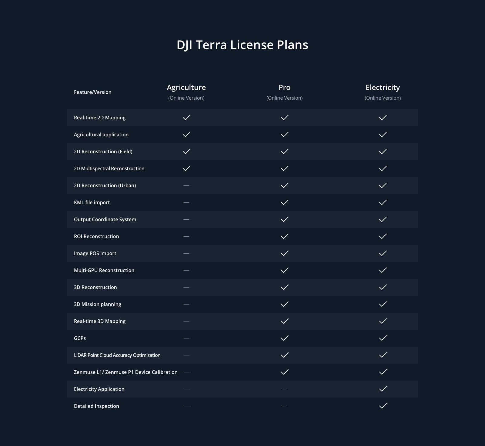
Terra licenses
| Features / Version |
advanced |
Per |
| 2-D mapping in real time |
YES |
YES |
| Applications in agriculture |
YES |
YES |
| Import of KML files |
YES |
YES |
| 2D reconstruction (Field) |
YES |
YES |
| 2D reconstruction (Urban) |
YES |
YES |
| 3D reconstruction |
NO |
YES |
| 3D flight orders |
NO |
YES
|